I will just hang out today and try to recover physically. I was not nearly as spent as I thought I would be, perhaps clean up a little. Michelle, Paul, and ziggy are doing another day of close support to fill in holes in our coverage. At end of day Ziggy, Ryan, and Pat are getting flown up to the top of the mountain above us to walk down. We believe no one has ever been up there before. Tomorrow, Pat and I and Michelle are scheduled to do close support, Ryan/Ziggy/Paul go to Lachley Mts., then we are done. BFC Kate is coming tomorrow, and we are getting flown out Fri. Out-brief on Sat., process data Sun., and fly to Christchurch Mon. morning.
So, we are winding down, trying to clean up camp a bit. 30 and sunny and calm, feels much warmer. Sandals and 1 pair of socks to keep my feet dry and cool, but they’re not cold. Very pleasant to just sit around and listen to my music on my iPod over the speakers. Solar is powering speakers, radio charge, and iPod charge. So, after last radio is charged, will try to charge my laptop.
I am scheduled to stay over 2 nights in CHC. I was going to take a train somewhere for a day. Ziggy and I are trying to contemplate a route, schedule, and cost.
Will try to call home this afternoon. No photos to post, just in camp all day.
Friday, January 23, 2009
Tuesday, January 20
Ryan, Pat and I were dropped off in Victoria Valley to collect 1-3 points that were previously scheduled for a helo support day, but canceled last week when we had so many weather problems. It should have been a pick-up, but Paul asked us to walk in, because he and Ziggy and Michell had close support all day and another helo was not available. They were important points, within the intersection of 3 images, so we would get a 3x return on our investment, but more thoughtful planning would have precluded us from doing this hike. Michelle asked the helo when they were done for the day if they could pick us up, but the schedule said no. So, she knew right away in the morning we were going to hike too far.
However, being dropped off about 10, and collecting the 3rd point by 12, we were at the imagery location where no more points were needed, and we had about 16 mi. to hump back. At least 3-4, possibly 5 mi., were uphill through a boulder field. I left a leather glove and hand-held GPS at one location, but I didn’t care. We tried to walk/hike/climb 40 min. and rest 10, but we sometimes had to stop sooner. I essentially did a marathon. Not as far, but very difficult terrain, hauling a 20-pound pack, and not in very good shape. We made it to camp at 8:10 p.m. Much more than 2 combined hike days should be. I forgot my camera battery before we left, so no photos. As it should be. This was a very down day. I never looked up once to see the scenery. My only memory is gravel and rocks and boulders underfoot.
When we finally got back, I drank 2 juice boxes, some water, and a beer, had some salty nuts, trying to avoid cramps tonight. Then Ziggy made halibut and rice pilaf which was very tasty. A couple of shots of scotch, and I hit the sack. I was very surprised to have slept, did not have cramps, and very little RLS.
Monday, January 19
Helo showed up about 1:30, about 45 min. earlier than scheduled, we were all scrambling, left two burners on. Thankfully the coffee pot did not totally evaporate and blow up...
On our way, Paul pointed out in Wright Valley a "Rock Glacier":

The Onyx River we hiked the other day:

We had to stop at Marble Point for fuel. The sea ice there is very fractured and looks like marble, I guess:
Two "Fuelies" live there for a few weeks at a time, and don't get many visitors other than helo pilots. So, for a group like us, they bake fresh cookies:

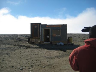
The Marble Point Visitor's Center:
Communications tower and shack, a couple of luxury trailers to live in, and the fuel tanks. The fuel gets driven across in the winter when the ice is thick. It saves a lot of helo time, fuel, and money to be able to refuel in the field where all the scientists need support:

I can't remember her name, but she works at Denali National Park in Alaska in the summer there, winter here. She loves being a fuelie...

We dropped off Ziggy and Ryan first near Lake Vanda, at one end of the valley. They will hike down to Canada Glacier from one end, Pat and I from the other. It doesn't look like much from this shot, but keep looking...

The face is at least 50' tall, more in some places:


Michelle and Paul were getting dropped off and picked up in a different valley surrounding Lake Bonnie.
Pat and I walked were dropped off at the head of Lake Hoar starting at Suess glacier and were to walk down to almost past Canada Glacier. Excellent weather, a bit below 32, but sunny, very little wind. Very peaceful, spectacular views. got good video and photos right up against the glaciers. The disappearing helo is the dot at the left just above the glacier:


higher up:

Pat in front for scale:

This glacier is at the top of the valley, and creates Lake Hoar:

We are leaving Suess Glacier and hiking along Lake Hoar. Canada Glacier is in the distance about 4 mi.:

After about an hour, we decided to look up the other way to see what the other side of the valley looked like, and we didn't look again:

We're finally within about a mile of Canada Glacier:


Hard to see in the compressed image, but there a a couple of "huts" (buildings) to the left of the glacier. There are also a few tents, but two hard to see. Usually biologists hang out there, but get flown in/out of McMurdo daily. They don't stay in camp like us.

Now were just across a little lake from Canada:

This gives you a feel for scale. We walked along the curved face for more than a mile:

Pat tried to call the home planet:

A boulder about the size of a pick-up, trapped for nearly a thousand years, will be released soon:

One of many locations where water is running off the top:

A recent calving, probably from this season, because the fallen ice looks so clean and slightly blue:

We collected our last point at the far end of the glacier, and had time for tea before the helo was scheduled to pick us up.

While we were sitting there, we heard a loud sound somewhere between and crack and a boom, and saw a live "calving". It lasted only a second, so I didn't capture it in action. However, here is what it looks like aftward. The large dirty block to the bottom left was along the ground and broke free with the other ice. It is about the size of a mini-cooper:

Ryan and Ziggy were dropped off first, before the SVB’s, but did not get notified of the location of the SVB drop. This could have been disastrous if the weather was bad. We had to fly around a bit to find them. Pat and I took some time to find the bags also. We knew where they were, but I couldn’t figure out how to measure distance on the hand-held GPS until we were almost there. As were were flying back, we could see Mt. Erubus across the Ross sea:

Other than that, Pat and I had a peaceful day.
Paul and Michelle ran into nematoad nazi’s at Lake Bonnie, and were photographed “Off the trail” while trying to cross a stream correctly……..by a person that wants imagery from Paul, but doesn’t understand that we are trying to help her… nematoads are small microscopic worms some biologists are studying.....
Fried frozen vegetarian enchiladas for dinner in the interest of speed. We got back late, and have an early morning start. Ended the day with a toast using 900 year old glacial ice in our Antarctica shot glasses with 10 year old scotch. Not sure who obtained the ice, or how.......

On our way, Paul pointed out in Wright Valley a "Rock Glacier":

The Onyx River we hiked the other day:

We had to stop at Marble Point for fuel. The sea ice there is very fractured and looks like marble, I guess:

Two "Fuelies" live there for a few weeks at a time, and don't get many visitors other than helo pilots. So, for a group like us, they bake fresh cookies:

The Marble Point Visitor's Center:

Communications tower and shack, a couple of luxury trailers to live in, and the fuel tanks. The fuel gets driven across in the winter when the ice is thick. It saves a lot of helo time, fuel, and money to be able to refuel in the field where all the scientists need support:

I can't remember her name, but she works at Denali National Park in Alaska in the summer there, winter here. She loves being a fuelie...

We dropped off Ziggy and Ryan first near Lake Vanda, at one end of the valley. They will hike down to Canada Glacier from one end, Pat and I from the other. It doesn't look like much from this shot, but keep looking...

The face is at least 50' tall, more in some places:


Michelle and Paul were getting dropped off and picked up in a different valley surrounding Lake Bonnie.
Pat and I walked were dropped off at the head of Lake Hoar starting at Suess glacier and were to walk down to almost past Canada Glacier. Excellent weather, a bit below 32, but sunny, very little wind. Very peaceful, spectacular views. got good video and photos right up against the glaciers. The disappearing helo is the dot at the left just above the glacier:


higher up:

Pat in front for scale:

This glacier is at the top of the valley, and creates Lake Hoar:

We are leaving Suess Glacier and hiking along Lake Hoar. Canada Glacier is in the distance about 4 mi.:

After about an hour, we decided to look up the other way to see what the other side of the valley looked like, and we didn't look again:

We're finally within about a mile of Canada Glacier:


Hard to see in the compressed image, but there a a couple of "huts" (buildings) to the left of the glacier. There are also a few tents, but two hard to see. Usually biologists hang out there, but get flown in/out of McMurdo daily. They don't stay in camp like us.

Now were just across a little lake from Canada:

This gives you a feel for scale. We walked along the curved face for more than a mile:

Pat tried to call the home planet:

A boulder about the size of a pick-up, trapped for nearly a thousand years, will be released soon:

One of many locations where water is running off the top:

A recent calving, probably from this season, because the fallen ice looks so clean and slightly blue:

We collected our last point at the far end of the glacier, and had time for tea before the helo was scheduled to pick us up.

While we were sitting there, we heard a loud sound somewhere between and crack and a boom, and saw a live "calving". It lasted only a second, so I didn't capture it in action. However, here is what it looks like aftward. The large dirty block to the bottom left was along the ground and broke free with the other ice. It is about the size of a mini-cooper:

Ryan and Ziggy were dropped off first, before the SVB’s, but did not get notified of the location of the SVB drop. This could have been disastrous if the weather was bad. We had to fly around a bit to find them. Pat and I took some time to find the bags also. We knew where they were, but I couldn’t figure out how to measure distance on the hand-held GPS until we were almost there. As were were flying back, we could see Mt. Erubus across the Ross sea:

Other than that, Pat and I had a peaceful day.
Paul and Michelle ran into nematoad nazi’s at Lake Bonnie, and were photographed “Off the trail” while trying to cross a stream correctly……..by a person that wants imagery from Paul, but doesn’t understand that we are trying to help her… nematoads are small microscopic worms some biologists are studying.....
Fried frozen vegetarian enchiladas for dinner in the interest of speed. We got back late, and have an early morning start. Ended the day with a toast using 900 year old glacial ice in our Antarctica shot glasses with 10 year old scotch. Not sure who obtained the ice, or how.......

Sunday, January 18
Sunny but cold this morning. All the 5-gal water jugs are at least partially frozen. We brought 2 into the tent, it will warm up today. My laptop won’t charge off solar, just slightly too many amps. We started generator to charge mine, Michelles, a phone, a radio, and of course Paul’s iPod so we could listen to old NPR broadcasts….whaddya know, and now some cooking show….
Ziggy is making powdered egges with ham, dried tomatoes, and dried onions fried in butter.
Ryan and Ziggy are going up sideways to some features, the rest of us are going to hike to the top of Bull Pass to Victoria valley to collect 1 point, event though we have helo time scheduled to drop a team in there at some point…
Here is a ventifact we saw on the way up. Pat's head is in the left eye of the monkey:

Another ventifact:

We hiked 6 miles up bull pass, 1500 increase in elevation. Not 6 mi. as crow flies, 6 mi. as measured by GPS in actual hiking. 1 point. Very cold and windy at the top of bull pass overlooking Victoria Valley. Here we are with the VV in the background:

I did ok until the last .6 mi. on the way back, which was all steeply down hill, and I had to go slower. Thermometer said temp was in the 40’s, and sunny, but wind came up later. Hopefully my dirty underwear tied to the tent won’t fly away.
Made it back:

I then took a wet wipes shower and put on deodorant, clean briefs, and brand new long underwear, and clean fleece jacket. Almost human...
Ziggy made spaghetti with chicken and carrots in butter garlic sauce. Very tasty.
Saturday, January 17
“heavy” snowfall last night. Flights are delayed. No one remembers such weather in bull pass or wright valley this time of year. Normally sunny and clear, sometimes warmer and milder, sometimes colder and windier. But never so many clouds, and for sure never any snow like we’ve had.
Ziggy made a couple of rock “steps” for us to clean our boots off before entering tent. It helps a little, but still a lot of sand is tracked in. So, Ryan made a large rock threshold, which worked even better. Ziggy also capped off our first 5-gal poop bucket, so a fresh one is ready.
The speakers are running off of solar power, and Ziggy just switched from B.B. King to Nepali music. Last night Paul’s iPod was connected, and everyone took turns choosing songs.
Everyone is reading or writing, Ziggy is still manipulating data on his ToughBook. Paul has made several Sat phone calls, and will explode soon. The snow has mostly melted off the sand in camp, but has made a mess of things. Helo’s are still on weather hold, so we are waiting until they cancel for the day before we make local contingency plans.
It takes a camera battery more than 1 hour to charge from the solar panel under these overcast conditions.
I took some photos of my boots with mountains in the background, and a couple turned out, but I may re-try again later. Paul said to send in to Red Wing.
Ryan and my tent is getting pretty stinky. It is tall enough to stand up in, but then you have to deal with the sock forest. There are cords around the top of the tent to hang things from. Excellent for drying socks, but not so much for aeromatic experiences. Also, when I unzip my jacket or take off my jeans to reveal the odor of my long underwear underneath, it is very bad – immediately obvious. Even worse, the smell when I open the fleece liner inside my sleeping bag. I sleep with that odor all night.
Yesterday while hiking one of the lenses fell out of my glasses. Luckily, into a pocket of little red. I’ve been using my back up pair, but Ziggy was able to repair last night in the Arctic Oven. Always bring a Polish repairman to every field camp. In Poland, one has to be able to repair everything.
We sat around the tent all day, reading, eating, headphones. Very cold, because it was heavy overcast and very windy. Some people slept in their tents for a few hours. Ryan and Pat went up a slope to investigate some features Ryan saw from the air, but turned out to be nothing. However, they found a cross fashioned from scrap wood and wire that had fallen from it’s base, so Ryan brought it down to camp and declared himself ruler of Ryantology.
Around dinner time, the sun came out, so we were able to run an iPod and speakers from solar. Pat comments on DF being wonderful dinner music, and Paul immediately replaces with his iPod and car talk.
Meetballs, Ragu, Rice, and mixed vegetables with peanut sauce, and for dessert, brown bread from a can. BFC Kate had sent a survival card game we felt obligated to play, so we did so wouldn’t embarrass Kate, but it was lame...
Friday, January 16
Oatmeal with pineapple, coffee, juice box, toasted English muffin with peanut butter for breakfeast
Tomorrow is underwear changing day…..everyone was counseled to bring a second set of long underwear. Ryan and mine needed changing several days ago already.......
Hikes today. We were all dropped off at 3 differenet points. Ziiggy and Ryan at Lake Vanda, Michelle and pat at the head of Wright valley, and they hiked down to lake Vanda:

Paul and I were dropped near the head of Onyx River, and hiked 7.75 miles collecting 5 points along the way. Here's how I roll:

Good weather at the beginning, but very windy by the end. My backpack was acting like a sail. I did a good job at keeping up, the boots make a huge difference. We wanted to make it back to our survival bags in time to get some ice from a glacier for the scotch. However, the helo spotted us first on their way into the valley to pick all of us up, and stopped by us first, even though we were last dropped off and closest to camp. We would have had time if they picked us up last. We were about 200m from the bags when they saw us.
Along the way, we saw rapids, several new washes, delta endings, 2 mummified seals, and ½ of a coconut. We were dropped off at lower right hut, which had a mummified seal scull on one of the guy lines.

Here is the Lower Right Valley Hut it is attached to:

Behind us, the opposite direction that we'll be walking, is the Ross Ice Shelf. Remember the Onyx River begins very near here, and flows away from the sea:

Paul near the head of the River:

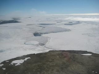
A better view of the Ice Shelf after we climbed up the valley a bit:

A lot of the day spent walking through sand:

Further down the river was running fairly rapidly:

The wind is usually strong in Wright Valley, regardless of season, so the glaciers are kept from coming down by wind. They actually evaporate mostly instead of melt:

Mummified seal, somewhere between hundreds and thousands of years old:

Paul near a "wash-out" that probably happened this season:

Me with a couple of the small glaciers on the other side of the valley in the background:

The coconut Paul found. This was a big deal. We marked it's location with a hand-held GPS, and Paul later called a biologist at McMurdo that was very excited, and was going to come out and date it as soon as possible:

After getting picked up in the helo, we could see Lake Vanda, that the Onyx drains into:

Our campsite from the air:

Pat made rice and chicken and vegetable stir fry, very good. BFC Kate sent us food re-stocks, including chips ahoy, cheese its, jerkey, and several flavor packets for cooking.
Tomorrow Paul, Michelle, and Ziggy will go to some peaks. I may help Ryan with some close points. Pat is going to call in another couple audio postcards. He did one from Lake Vanda today.
And, of course, every night..........

Tomorrow is underwear changing day…..everyone was counseled to bring a second set of long underwear. Ryan and mine needed changing several days ago already.......
Hikes today. We were all dropped off at 3 differenet points. Ziiggy and Ryan at Lake Vanda, Michelle and pat at the head of Wright valley, and they hiked down to lake Vanda:

Paul and I were dropped near the head of Onyx River, and hiked 7.75 miles collecting 5 points along the way. Here's how I roll:

Good weather at the beginning, but very windy by the end. My backpack was acting like a sail. I did a good job at keeping up, the boots make a huge difference. We wanted to make it back to our survival bags in time to get some ice from a glacier for the scotch. However, the helo spotted us first on their way into the valley to pick all of us up, and stopped by us first, even though we were last dropped off and closest to camp. We would have had time if they picked us up last. We were about 200m from the bags when they saw us.
Along the way, we saw rapids, several new washes, delta endings, 2 mummified seals, and ½ of a coconut. We were dropped off at lower right hut, which had a mummified seal scull on one of the guy lines.

Here is the Lower Right Valley Hut it is attached to:

Behind us, the opposite direction that we'll be walking, is the Ross Ice Shelf. Remember the Onyx River begins very near here, and flows away from the sea:

Paul near the head of the River:

A better view of the Ice Shelf after we climbed up the valley a bit:

A lot of the day spent walking through sand:

Further down the river was running fairly rapidly:

The wind is usually strong in Wright Valley, regardless of season, so the glaciers are kept from coming down by wind. They actually evaporate mostly instead of melt:

Mummified seal, somewhere between hundreds and thousands of years old:

Paul near a "wash-out" that probably happened this season:

Me with a couple of the small glaciers on the other side of the valley in the background:

The coconut Paul found. This was a big deal. We marked it's location with a hand-held GPS, and Paul later called a biologist at McMurdo that was very excited, and was going to come out and date it as soon as possible:

After getting picked up in the helo, we could see Lake Vanda, that the Onyx drains into:

Our campsite from the air:

Pat made rice and chicken and vegetable stir fry, very good. BFC Kate sent us food re-stocks, including chips ahoy, cheese its, jerkey, and several flavor packets for cooking.
Tomorrow Paul, Michelle, and Ziggy will go to some peaks. I may help Ryan with some close points. Pat is going to call in another couple audio postcards. He did one from Lake Vanda today.
And, of course, every night..........

Subscribe to:
Posts (Atom)
